Showing posts with label Maps. Show all posts

Thursday, 16 July 2009

Maps

MAPS

How can I put this? How about

noooooooooo
!

After spending two or three days sorting this map out, I made one unfortunate keyboard click - partly frustration with Google becoming a little cumbersome with over 300 place markers on the map - and this map was accidentally deleted from the Google site.

Yes, it's gone. If you've come to this page, looking for it, I'm sorry (and slightly depressed).

There is the earlier Google Earth version of the map (not quite so many places but pretty good) still visible under Maps on the main www.victorianlondon.org site.

Unfortunately, I don't really have the time or energy to rebuild - so I better shut up and chalk it up to experience. Grrrr.

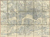
I've made an effort to map Victorian London before on GoogleEarth, but Google Maps is more accessible and user-friendly, so I've now imported the old map and added a few things. You can see it below, or as a full page here.

I'd like to add a lot more to this map, and wonder if anyone has suggestions for particular Victorian buildings, past or present that should be pinpointed? Obviously, I have a few ideas myself ... but any favourites that I've missed?

Tuesday, 30 January 2007

Maps in Print

Reynolds Map, 1895 MAPS IN PRINT

A reader inquires whether I can supply a print copy of the 1895 Reynolds Map of London. The short answer is no; but anyone on the look-out for print maps of Victorian London should try
1. www.abebooks.com ... search under "London" and "Map" or "atlas" in the title and limit years ... this will find lots of Victorian London street maps (often rather expensive, as some are collectors items)
2. www.motco.com sell print reproductions of sections of the incredible 1862 Stanford map.
3. The LSE Archive sell print reproductions of sections of the 1898-9 Booth Poverty Maps.
4. An extensive 1888 Bacon map has been reprinted in book form.
5. www.oldhousebooks.co.uk also sell a reprint of an 1840s map, and Baedecker guides from the end of the century.
I'd be interested to know of other reprints, if anyone has come across them.

Saturday, 27 January 2007

Holborn Haunts

Holborn map
HOLBORN HAUNTS

A reader inquires about the location of the Holborn Casino, an infamous dance-hall/night-club of the 1860s/1870s which features in my third novel, The Welfare of the Dead. It was replaced by the Holborn Restaurant and was located in the area opposite today's Holborn tube station. The map attached shows Holborn in 1899 ... Kingsway was not yet built, with slums still around Great Wild Street and Clare Market in the south. Also a lost theatre, the Jodrell; two lost music halls, the Royal and the seemingly tiny Middlesex. Plus, if you look closely, an intimation of the British Museum Station on the new central line, which would appear in mid 1900. For the rest of the Pocket Map of London (very good on theatres) see my site.

Wednesday, 17 January 2007

Maps

Parish Boundaries 1877MAPS

A site after my own heart is MAPCO and, of course, the London section. I've just noticed that there's three new Victorian maps on there, since I last looked, and have added them to my own list. These include a beautifully detailed map of all parish boundaries in 1877 - great stuff!

Wednesday, 10 January 2007

Two Exhibitions

The Fair Toxophilites, William Frith, 1872 (not sure if this particular picture is at this exhibition, mind you, ed.)Two Exhibitions

London : A Life in Maps (until 4 March 2007)
A British Library showcase of London maps. The virtual exhibition links through to the Collect Britain site, which is worth a look in itself

William Powell Frith : Painting the Victorian Age (until 4 March 2007)
An exhibition of the great painter at the Guildhall Art Gallery.